


corbel les égaux

pierrounet
User

Length
6.6 km

Max alt
1023 m

Uphill gradient
303 m
Km-Effort
10.6 km

Min alt
754 m

Downhill gradient
302 m
Boucle
Yes
Creation date :
2025-07-14 07:05:05.525
Updated on :
2025-07-14 09:48:49.735
2h43
Difficulty : Medium

FREE GPS app for hiking
 SityTrail
IGN / Geographical institutes
SityTrail Plus
The world is yours!
About
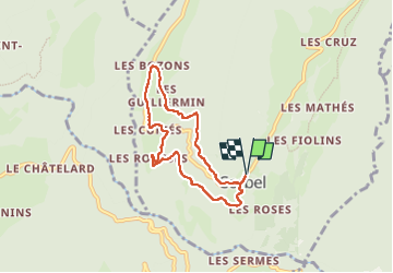
Trail Walking of 6.6 km to be discovered at Auvergne-Rhône-Alpes, Savoy, Corbel. This trail is proposed by pierrounet.
Positioning
Country:
France
Region :
Auvergne-Rhône-Alpes
Department/Province :
Savoy
Municipality :
Corbel
Location:
Unknown
Start:(Dec)
Start:(UTM)
721020 ; 5034640 (31T) N.
Comments