


Sérigas Grotte Dargilan 15km

thonyc
User GUIDE
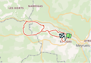

Length
15 km

Max alt
1006 m

Uphill gradient
549 m
Km-Effort
22 km

Min alt
613 m

Downhill gradient
549 m
Boucle
Yes
Creation date :
2025-07-14 12:53:16.209
Updated on :
2025-07-14 13:21:07.787
5h04
Difficulty : Medium

FREE GPS app for hiking
 SityTrail
IGN / Geographical institutes
SityTrail Plus
The world is yours!
About
Trail On foot of 15 km to be discovered at Occitania, Lozère, Meyrueis. This trail is proposed by thonyc.
Positioning
Country:
France
Region :
Occitania
Department/Province :
Lozère
Municipality :
Meyrueis
Location:
Unknown
Start:(Dec)
Start:(UTM)
532538 ; 4892130 (31T) N.
Comments