


la chalo

ISAGIL
User
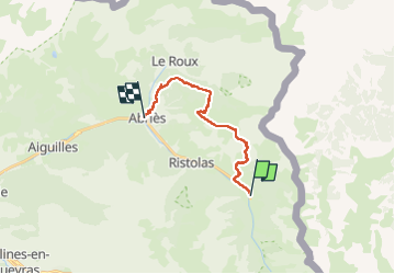

Length
16.1 km

Max alt
2584 m

Uphill gradient
948 m
Km-Effort
29 km

Min alt
1552 m

Downhill gradient
1089 m
Boucle
No
Creation date :
2025-07-18 05:53:25.71
Updated on :
2025-07-18 13:05:21.269
6h32
Difficulty : Very difficult

FREE GPS app for hiking
 SityTrail
IGN / Geographical institutes
SityTrail Plus
The world is yours!
About
Trail Walking of 16.1 km to be discovered at Provence-Alpes-Côte d'Azur, Hautes-Alpes, Abriès-Ristolas. This trail is proposed by ISAGIL.
Description
la chaleur abries
Positioning
Country:
France
Region :
Provence-Alpes-Côte d'Azur
Department/Province :
Hautes-Alpes
Municipality :
Abriès-Ristolas
Location:
Ristolas
Start:(Dec)
Start:(UTM)
341138 ; 4958186 (32T) N.
Comments