


liverdun frouard

any1950
User
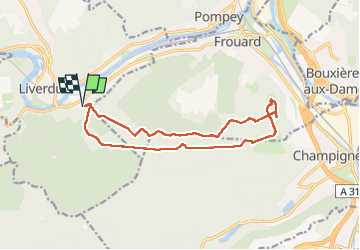

Length
14.1 km

Max alt
361 m

Uphill gradient
224 m
Km-Effort
17.1 km

Min alt
219 m

Downhill gradient
222 m
Boucle
Yes
Creation date :
2025-07-18 12:10:34.434
Updated on :
2025-07-18 16:25:07.693
4h13
Difficulty : Medium

FREE GPS app for hiking
 SityTrail
IGN / Geographical institutes
SityTrail Plus
The world is yours!
About
Trail Walking of 14.1 km to be discovered at Grand Est, Meurthe-et-Moselle, Liverdun. This trail is proposed by any1950.
Description
marche
Positioning
Country:
France
Region :
Grand Est
Department/Province :
Meurthe-et-Moselle
Municipality :
Liverdun
Location:
Unknown
Start:(Dec)
Start:(UTM)
285070 ; 5403256 (32U) N.
Comments