


UTTJ 2015-1

bourel.jacques
User
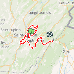

Length
56 km

Max alt
1294 m

Uphill gradient
3425 m
Km-Effort
100 km

Min alt
398 m

Downhill gradient
2866 m
Boucle
No
Creation date :
2015-08-02 00:00:00.0
Updated on :
2015-08-02 00:00:00.0
20h04
Difficulty : Very difficult

FREE GPS app for hiking
 SityTrail
IGN / Geographical institutes
SityTrail Plus
The world is yours!
About
Trail Running of 56 km to be discovered at Bourgogne-Franche-Comté, Jura, Saint-Claude. This trail is proposed by bourel.jacques.
Description
1ère étape de l'UltraTrail Tour du Jura 2015
Samedi 11 juillet 2015
Positioning
Country:
France
Region :
Bourgogne-Franche-Comté
Department/Province :
Jura
Municipality :
Saint-Claude
Location:
Unknown
Start:(Dec)
Start:(UTM)
721083 ; 5140105 (31T) N.
Comments