


20/07/25 - Trimbach au val

delm
User
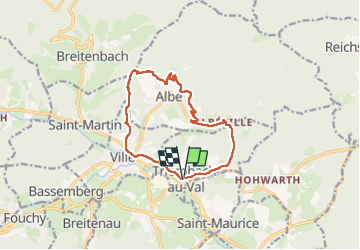

Length
11.9 km

Max alt
463 m

Uphill gradient
434 m
Km-Effort
17.7 km

Min alt
257 m

Downhill gradient
433 m
Boucle
Yes
Creation date :
2025-07-20 09:01:24.0
Updated on :
2025-07-20 13:19:13.092

FREE GPS app for hiking
 SityTrail
IGN / Geographical institutes
SityTrail Plus
The world is yours!
About
Trail of 11.9 km to be discovered at Grand Est, Bas-Rhin, Triembach-au-Val. This trail is proposed by delm.
Positioning
Country:
France
Region :
Grand Est
Department/Province :
Bas-Rhin
Municipality :
Triembach-au-Val
Location:
Unknown
Start:(Dec)
Start:(UTM)
375830 ; 5355190 (32U) N.
Comments