


Vire d'Archiane

Atchoum26
User
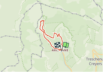

Length
12.5 km

Max alt
1730 m

Uphill gradient
1286 m
Km-Effort
30 km

Min alt
755 m

Downhill gradient
1286 m
Boucle
Yes
Creation date :
2025-07-20 06:17:35.028
Updated on :
2025-07-20 14:21:18.084
6h33
Difficulty : Difficult

FREE GPS app for hiking
 SityTrail
IGN / Geographical institutes
SityTrail Plus
The world is yours!
About
Trail Walking of 12.5 km to be discovered at Auvergne-Rhône-Alpes, Drôme, Châtillon-en-Diois. This trail is proposed by Atchoum26.
Description
Quelques passages difficiles
Une partie rappel mais possible de descalader
Positioning
Country:
France
Region :
Auvergne-Rhône-Alpes
Department/Province :
Drôme
Municipality :
Châtillon-en-Diois
Location:
Treschenu-Creyers
Start:(Dec)
Start:(UTM)
698455 ; 4957723 (31T) N.
Comments