


Le Mont Buet

bourel.jacques
User
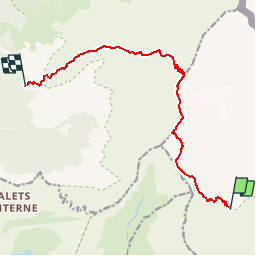

Length
11.6 km

Max alt
3083 m

Uphill gradient
1195 m
Km-Effort
27 km

Min alt
1934 m

Downhill gradient
1173 m
Boucle
No
Creation date :
2015-08-03 00:00:00.0
Updated on :
2015-08-03 00:00:00.0
5h29
Difficulty : Very difficult

FREE GPS app for hiking
 SityTrail
IGN / Geographical institutes
SityTrail Plus
The world is yours!
About
Trail Walking of 11.6 km to be discovered at Auvergne-Rhône-Alpes, Upper Savoy, Vallorcine. This trail is proposed by bourel.jacques.
Description
Depuis le refuge de la Pierre à Bérard jusqu'au refuge de Grenairon.
Passage aérien avec câbles et échelles en redescendant du Buet vers le plan du Buet.
Positioning
Country:
France
Region :
Auvergne-Rhône-Alpes
Department/Province :
Upper Savoy
Municipality :
Vallorcine
Location:
Unknown
Start:(Dec)
Start:(UTM)
334973 ; 5096606 (32T) N.
Comments