


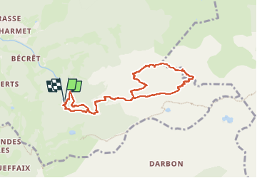
La dent d’Oche 2

algecko
User


4h57
Difficulty : Very difficult

FREE GPS app for hiking
 SityTrail
IGN / Geographical institutes
SityTrail Plus
The world is yours!
About
Trail Walking of 9 km to be discovered at Auvergne-Rhône-Alpes, Upper Savoy, Bernex. This trail is proposed by algecko.
Description
A la montée après le col de Rebollion, passage assez difficile dans la cheminée avec chaines. A la descente entre la Dent d'Oche et le col de Planchamp passages très délicats mais avec chaines. Le reste du parcours et correct.
Positioning
Comments