


s2

JL GUILLEMOTE
User
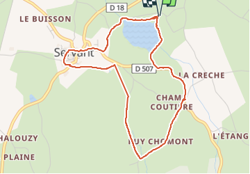

Length
4.7 km

Max alt
600 m

Uphill gradient
118 m
Km-Effort
6.3 km

Min alt
520 m

Downhill gradient
119 m
Boucle
Yes
Creation date :
2025-07-22 15:38:46.069
Updated on :
2025-07-22 17:05:22.01
1h26
Difficulty : Medium

FREE GPS app for hiking
 SityTrail
IGN / Geographical institutes
SityTrail Plus
The world is yours!
About
Trail Walking of 4.7 km to be discovered at Auvergne-Rhône-Alpes, Puy-de-Dôme, Servant. This trail is proposed by JL GUILLEMOTE.
Positioning
Country:
France
Region :
Auvergne-Rhône-Alpes
Department/Province :
Puy-de-Dôme
Municipality :
Servant
Location:
Unknown
Start:(Dec)
Start:(UTM)
495296 ; 5109811 (31T) N.
Comments