


s3

JL GUILLEMOTE
User
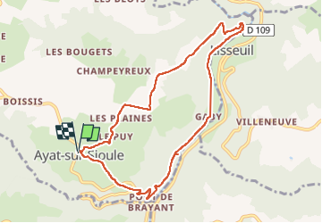

Length
9.2 km

Max alt
570 m

Uphill gradient
274 m
Km-Effort
12.8 km

Min alt
365 m

Downhill gradient
275 m
Boucle
Yes
Creation date :
2025-07-23 10:17:18.086
Updated on :
2025-07-23 13:56:31.25
2h57
Difficulty : Difficult

FREE GPS app for hiking
 SityTrail
IGN / Geographical institutes
SityTrail Plus
The world is yours!
About
Trail Walking of 9.2 km to be discovered at Auvergne-Rhône-Alpes, Puy-de-Dôme, Ayat-sur-Sioule. This trail is proposed by JL GUILLEMOTE.
Positioning
Country:
France
Region :
Auvergne-Rhône-Alpes
Department/Province :
Puy-de-Dôme
Municipality :
Ayat-sur-Sioule
Location:
Unknown
Start:(Dec)
Start:(UTM)
491442 ; 5099562 (31T) N.
Comments