


Etape 4 V2 - Saint-Vaast - Le Varilmesnil - 65 km

jeanmarcMasson
User GUIDE
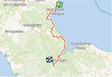

Length
65 km

Max alt
85 m

Uphill gradient
365 m
Km-Effort
69 km

Min alt
-5 m

Downhill gradient
350 m
Boucle
No
Creation date :
2025-07-23 15:00:53.377
Updated on :
2025-07-23 15:03:01.953
--
Difficulty : Very difficult

FREE GPS app for hiking
 SityTrail
IGN / Geographical institutes
SityTrail Plus
The world is yours!
About
Trail Bicycle tourism of 65 km to be discovered at Normandy, Manche, Saint-Vaast-la-Hougue. This trail is proposed by jeanmarcMasson.
Positioning
Country:
France
Region :
Normandy
Department/Province :
Manche
Municipality :
Saint-Vaast-la-Hougue
Location:
Unknown
Start:(Dec)
Start:(UTM)
624943 ; 5494188 (30U) N.
Comments