


Puy des Chaires

jeriom
User
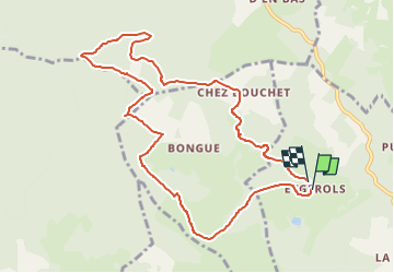

Length
10.4 km

Max alt
932 m

Uphill gradient
261 m
Km-Effort
13.8 km

Min alt
817 m

Downhill gradient
256 m
Boucle
Yes
Creation date :
2025-07-23 17:10:00.722
Updated on :
2025-07-23 17:10:04.604
3h08
Difficulty : Difficult

FREE GPS app for hiking
 SityTrail
IGN / Geographical institutes
SityTrail Plus
The world is yours!
About
Trail Walking of 10.4 km to be discovered at New Aquitaine, Corrèze, Eygurande. This trail is proposed by jeriom.
Positioning
Country:
France
Region :
New Aquitaine
Department/Province :
Corrèze
Municipality :
Eygurande
Location:
Unknown
Start:(Dec)
Start:(UTM)
451290 ; 5060823 (31T) N.
Comments