


250724 thelis bas

Julliengamo
User

Length
864 m

Max alt
1153 m

Uphill gradient
11 m
Km-Effort
1 km

Min alt
1135 m

Downhill gradient
11 m
Boucle
Yes
Creation date :
2025-07-24 11:55:28.447
Updated on :
2025-07-24 15:01:36.107
3h05
Difficulty : Very easy

FREE GPS app for hiking
 SityTrail
IGN / Geographical institutes
SityTrail Plus
The world is yours!
About
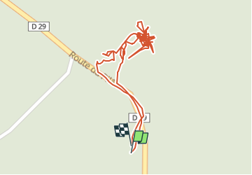
Trail Other activity of 864 m to be discovered at Auvergne-Rhône-Alpes, Loire, Thélis-la-Combe. This trail is proposed by Julliengamo.
Positioning
Country:
France
Region :
Auvergne-Rhône-Alpes
Department/Province :
Loire
Municipality :
Thélis-la-Combe
Location:
Unknown
Start:(Dec)
Start:(UTM)
620546 ; 5023852 (31T) N.
Comments