


Projet Amicale Anjou

d.rognon
User
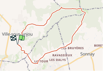

Length
9.5 km

Max alt
405 m

Uphill gradient
209 m
Km-Effort
12.3 km

Min alt
236 m

Downhill gradient
213 m
Boucle
Yes
Creation date :
2025-07-25 10:14:26.901
Updated on :
2025-07-25 10:14:57.775
2h48
Difficulty : Difficult

FREE GPS app for hiking
 SityTrail
IGN / Geographical institutes
SityTrail Plus
The world is yours!
About
Trail Walking of 9.5 km to be discovered at Auvergne-Rhône-Alpes, Isère, Ville-sous-Anjou. This trail is proposed by d.rognon.
Positioning
Country:
France
Region :
Auvergne-Rhône-Alpes
Department/Province :
Isère
Municipality :
Ville-sous-Anjou
Location:
Unknown
Start:(Dec)
Start:(UTM)
645944 ; 5024473 (31T) N.
Comments