


Cerces/Thabor

DUCLUZEAU
User
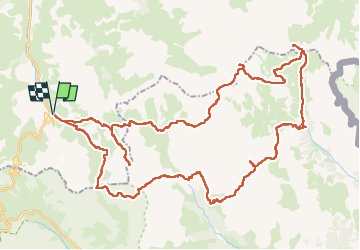

Length
63 km

Max alt
3168 m

Uphill gradient
4470 m
Km-Effort
122 km

Min alt
1904 m

Downhill gradient
4466 m
Boucle
Yes
Creation date :
2025-07-26 04:33:55.751
Updated on :
2025-07-26 04:33:58.558
27h47
Difficulty : Very difficult

FREE GPS app for hiking
 SityTrail
IGN / Geographical institutes
SityTrail Plus
The world is yours!
About
Trail Walking of 63 km to be discovered at Auvergne-Rhône-Alpes, Savoy, Valloire. This trail is proposed by DUCLUZEAU.
Positioning
Country:
France
Region :
Auvergne-Rhône-Alpes
Department/Province :
Savoy
Municipality :
Valloire
Location:
Unknown
Start:(Dec)
Start:(UTM)
298203 ; 4996167 (32T) N.
Comments