


Arvoin 2

algecko
User
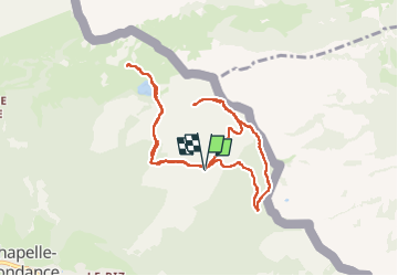

Length
10 km

Max alt
1897 m

Uphill gradient
467 m
Km-Effort
16.2 km

Min alt
1589 m

Downhill gradient
465 m
Boucle
Yes
Creation date :
2025-07-26 06:34:12.0
Updated on :
2025-07-26 11:42:00.572
2h42
Difficulty : Medium

FREE GPS app for hiking
 SityTrail
IGN / Geographical institutes
SityTrail Plus
The world is yours!
About
Trail Walking of 10 km to be discovered at Auvergne-Rhône-Alpes, Upper Savoy, La Chapelle-d'Abondance. This trail is proposed by algecko.
Positioning
Country:
France
Region :
Auvergne-Rhône-Alpes
Department/Province :
Upper Savoy
Municipality :
La Chapelle-d'Abondance
Location:
Unknown
Start:(Dec)
Start:(UTM)
332022 ; 5130321 (32T) N.
Comments