


mirmande ... Ã voir

stef789
User GUIDE

Length
1.6 km

Max alt
245 m

Uphill gradient
70 m
Km-Effort
2.6 km

Min alt
169 m

Downhill gradient
68 m
Boucle
Yes
Creation date :
2025-07-27 08:19:55.209
Updated on :
2025-07-27 09:11:28.013
47m
Difficulty : Easy

FREE GPS app for hiking
 SityTrail
IGN / Geographical institutes
SityTrail Plus
The world is yours!
About
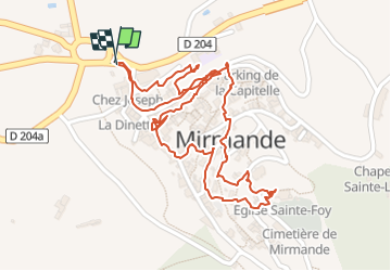
Trail Walking of 1.6 km to be discovered at Auvergne-Rhône-Alpes, Drôme, Mirmande. This trail is proposed by stef789.
Photos


Positioning
Country:
France
Region :
Auvergne-Rhône-Alpes
Department/Province :
Drôme
Municipality :
Mirmande
Location:
Unknown
Start:(Dec)
Start:(UTM)
645282 ; 4951202 (31T) N.
Comments