


randogps81-620

tercla
User
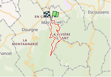

Length
9.9 km

Max alt
589 m

Uphill gradient
472 m
Km-Effort
16.2 km

Min alt
275 m

Downhill gradient
474 m
Boucle
Yes
Creation date :
2025-07-27 12:58:50.898
Updated on :
2025-07-27 13:02:39.439
3h40
Difficulty : Easy

FREE GPS app for hiking
 SityTrail
IGN / Geographical institutes
SityTrail Plus
The world is yours!
About
Trail On foot of 9.9 km to be discovered at Occitania, Tarn, Massaguel. This trail is proposed by tercla.


Positioning
Country:
France
Region :
Occitania
Department/Province :
Tarn
Municipality :
Massaguel
Location:
Unknown
Start:(Dec)
Start:(UTM)
432101 ; 4815853 (31T) N.
Comments