


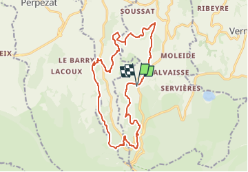
Douharesse haut la roche Sanadoire et Tuilière 19 km 660 dénivelé

jeanic63
User

Length
18.6 km

Max alt
1221 m

Uphill gradient
656 m
Km-Effort
27 km

Min alt
968 m

Downhill gradient
658 m
Boucle
Yes
Creation date :
2025-07-27 19:03:18.581
Updated on :
2025-07-28 18:54:44.375
6h13
Difficulty : Medium

FREE GPS app for hiking
 SityTrail
IGN / Geographical institutes
SityTrail Plus
The world is yours!
About
Trail On foot of 18.6 km to be discovered at Auvergne-Rhône-Alpes, Puy-de-Dôme, Orcival. This trail is proposed by jeanic63.
Description
Départ parking pique nique Douharesse haut
Positioning
Country:
France
Region :
Auvergne-Rhône-Alpes
Department/Province :
Puy-de-Dôme
Municipality :
Orcival
Location:
Unknown
Start:(Dec)
Start:(UTM)
486246 ; 5055138 (31T) N.
Comments