


R2 Bièvres-Gare

Jack-94
User
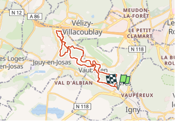

Length
15.5 km

Max alt
185 m

Uphill gradient
329 m
Km-Effort
19.9 km

Min alt
74 m

Downhill gradient
328 m
Boucle
Yes
Creation date :
2025-07-27 19:23:54.959
Updated on :
2025-07-27 19:24:22.241
4h30
Difficulty : Very difficult

FREE GPS app for hiking
 SityTrail
IGN / Geographical institutes
SityTrail Plus
The world is yours!
About
Trail Walking of 15.5 km to be discovered at Ile-de-France, Essonne, Bièvres. This trail is proposed by Jack-94.

Positioning
Country:
France
Region :
Ile-de-France
Department/Province :
Essonne
Municipality :
Bièvres
Location:
Unknown
Start:(Dec)
Start:(UTM)
442343 ; 5400124 (31U) N.
Comments