


a

bruno38
User
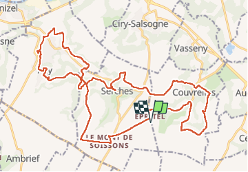

Length
27 km

Max alt
160 m

Uphill gradient
496 m
Km-Effort
34 km

Min alt
58 m

Downhill gradient
496 m
Boucle
Yes
Creation date :
2025-07-28 06:54:28.806
Updated on :
2025-07-28 13:21:23.255
6h26
Difficulty : Very difficult

FREE GPS app for hiking
 SityTrail
IGN / Geographical institutes
SityTrail Plus
The world is yours!
About
Trail Walking of 27 km to be discovered at Hauts-de-France, Aisne, Couvrelles. This trail is proposed by bruno38.
Description
acy soissons
Positioning
Country:
France
Region :
Hauts-de-France
Department/Province :
Aisne
Municipality :
Couvrelles
Location:
Unknown
Start:(Dec)
Start:(UTM)
533940 ; 5464134 (31U) N.
Comments