


og-Bièvre

Jack-94
User
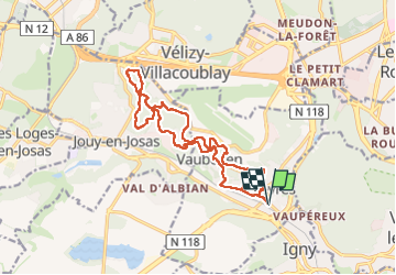

Length
16.2 km

Max alt
184 m

Uphill gradient
347 m
Km-Effort
21 km

Min alt
74 m

Downhill gradient
346 m
Boucle
Yes
Creation date :
2025-07-28 07:32:28.415
Updated on :
2025-07-28 14:26:37.5
6h53
Difficulty : Very difficult

FREE GPS app for hiking
 SityTrail
IGN / Geographical institutes
SityTrail Plus
The world is yours!
About
Trail Walking of 16.2 km to be discovered at Ile-de-France, Essonne, Bièvres. This trail is proposed by Jack-94.
Positioning
Country:
France
Region :
Ile-de-France
Department/Province :
Essonne
Municipality :
Bièvres
Location:
Unknown
Start:(Dec)
Start:(UTM)
442359 ; 5400123 (31U) N.
Comments