


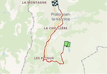
2025_07_Ã8_J7 retour Pralo depuis La Valette

Chamois30
User

Length
12 km

Max alt
2609 m

Uphill gradient
161 m
Km-Effort
18 km

Min alt
1414 m

Downhill gradient
1298 m
Boucle
No
Creation date :
2025-07-28 05:44:43.81
Updated on :
2025-07-29 11:30:16.344
3h13
Difficulty : Medium

FREE GPS app for hiking
 SityTrail
IGN / Geographical institutes
SityTrail Plus
The world is yours!
About
Trail Walking of 12 km to be discovered at Auvergne-Rhône-Alpes, Savoy, Pralognan-la-Vanoise. This trail is proposed by Chamois30.
Positioning
Country:
France
Region :
Auvergne-Rhône-Alpes
Department/Province :
Savoy
Municipality :
Pralognan-la-Vanoise
Location:
Unknown
Start:(Dec)
Start:(UTM)
321734 ; 5024764 (32T) N.
Comments