


fort de t'aime MPK

pierrounet
User
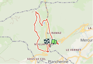

Length
7.9 km

Max alt
1078 m

Uphill gradient
342 m
Km-Effort
12.5 km

Min alt
841 m

Downhill gradient
343 m
Boucle
Yes
Creation date :
2025-07-30 06:47:11.734
Updated on :
2025-07-30 14:15:23.657
3h00
Difficulty : Difficult

FREE GPS app for hiking
 SityTrail
IGN / Geographical institutes
SityTrail Plus
The world is yours!
About
Trail Walking of 7.9 km to be discovered at Auvergne-Rhône-Alpes, Savoy, Mercury. This trail is proposed by pierrounet.
Positioning
Country:
France
Region :
Auvergne-Rhône-Alpes
Department/Province :
Savoy
Municipality :
Mercury
Location:
Unknown
Start:(Dec)
Start:(UTM)
290581 ; 5061107 (32T) N.
Comments