


Footing Courseulles 4

yannick-p
User
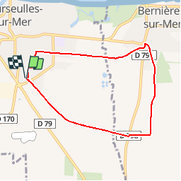

Length
6.9 km

Max alt
36 m

Uphill gradient
41 m
Km-Effort
7.5 km

Min alt
6 m

Downhill gradient
42 m
Boucle
Yes
Creation date :
2015-08-04 00:00:00.0
Updated on :
2015-08-04 00:00:00.0
35m
Difficulty : Easy

FREE GPS app for hiking
 SityTrail
IGN / Geographical institutes
SityTrail Plus
The world is yours!
About
Trail Running of 6.9 km to be discovered at Normandy, Calvados, Courseulles-sur-Mer. This trail is proposed by yannick-p.
Positioning
Country:
France
Region :
Normandy
Department/Province :
Calvados
Municipality :
Courseulles-sur-Mer
Location:
Unknown
Start:(Dec)
Start:(UTM)
685026 ; 5466506 (30U) N.
Comments