


Tête de la Dame depuis Malatras

m.rozeron
User
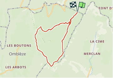

Length
15.6 km

Max alt
1501 m

Uphill gradient
490 m
Km-Effort
22 km

Min alt
1197 m

Downhill gradient
490 m
Boucle
Yes
Creation date :
2025-07-30 09:39:02.16
Updated on :
2025-07-30 20:01:25.46
5h50
Difficulty : Very difficult

FREE GPS app for hiking
 SityTrail
IGN / Geographical institutes
SityTrail Plus
The world is yours!
About
Trail Walking of 15.6 km to be discovered at Auvergne-Rhône-Alpes, Drôme, Bouvante. This trail is proposed by m.rozeron.
Positioning
Country:
France
Region :
Auvergne-Rhône-Alpes
Department/Province :
Drôme
Municipality :
Bouvante
Location:
Unknown
Start:(Dec)
Start:(UTM)
680524 ; 4973964 (31T) N.
Comments