


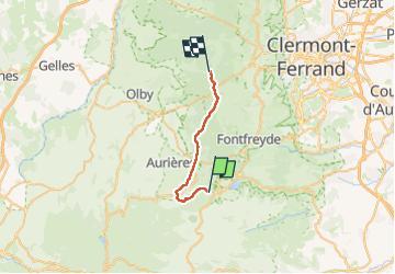
La Garandie - le Puy de Dôme

Gegetop
User

Length
19.1 km

Max alt
1098 m

Uphill gradient
404 m
Km-Effort
24 km

Min alt
967 m

Downhill gradient
331 m
Boucle
No
Creation date :
2025-06-20 07:36:37.772
Updated on :
2025-07-31 08:40:05.073
4h36
Difficulty : Medium

FREE GPS app for hiking
 SityTrail
IGN / Geographical institutes
SityTrail Plus
The world is yours!
About
Trail Walking of 19.1 km to be discovered at Auvergne-Rhône-Alpes, Puy-de-Dôme, Aydat. This trail is proposed by Gegetop.
Description
Retour après la nuit au lodge des 2 mondes.
Positioning
Country:
France
Region :
Auvergne-Rhône-Alpes
Department/Province :
Puy-de-Dôme
Municipality :
Aydat
Location:
Unknown
Start:(Dec)
Start:(UTM)
496436 ; 5056072 (31T) N.
Comments