


sauve

JLDECK
User
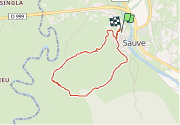

Length
4.1 km

Max alt
154 m

Uphill gradient
67 m
Km-Effort
5 km

Min alt
107 m

Downhill gradient
69 m
Boucle
Yes
Creation date :
2025-07-30 16:30:02.552
Updated on :
2025-07-31 10:01:16.507
1h12
Difficulty : Very easy

FREE GPS app for hiking
 SityTrail
IGN / Geographical institutes
SityTrail Plus
The world is yours!
About
Trail Walking of 4.1 km to be discovered at Occitania, Gard, Sauve. This trail is proposed by JLDECK.
Positioning
Country:
France
Region :
Occitania
Department/Province :
Gard
Municipality :
Sauve
Location:
Unknown
Start:(Dec)
Start:(UTM)
576182 ; 4865903 (31T) N.
Comments