


col Aizac, fau faye

Alaint07
User
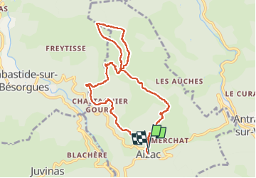

Length
9.6 km

Max alt
1161 m

Uphill gradient
574 m
Km-Effort
17.3 km

Min alt
641 m

Downhill gradient
597 m
Boucle
Yes
Creation date :
2025-07-31 07:16:06.08
Updated on :
2025-07-31 12:18:46.752
3h12
Difficulty : Difficult

FREE GPS app for hiking
 SityTrail
IGN / Geographical institutes
SityTrail Plus
The world is yours!
About
Trail Walking of 9.6 km to be discovered at Auvergne-Rhône-Alpes, Ardèche, Aizac. This trail is proposed by Alaint07.
Positioning
Country:
France
Region :
Auvergne-Rhône-Alpes
Department/Province :
Ardèche
Municipality :
Aizac
Location:
Unknown
Start:(Dec)
Start:(UTM)
605362 ; 4952140 (31T) N.
Comments