


Pressignac Vicq 8,8km

amelie14
User
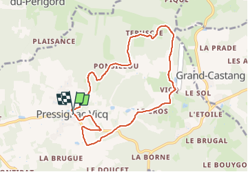

Length
8.8 km

Max alt
205 m

Uphill gradient
163 m
Km-Effort
11 km

Min alt
142 m

Downhill gradient
162 m
Boucle
Yes
Creation date :
2025-08-01 10:18:57.062
Updated on :
2025-08-01 11:44:06.94
53m
Difficulty : Medium

FREE GPS app for hiking
 SityTrail
IGN / Geographical institutes
SityTrail Plus
The world is yours!
About
Trail Trail of 8.8 km to be discovered at New Aquitaine, Dordogne, Pressignac-Vicq. This trail is proposed by amelie14.
Positioning
Country:
France
Region :
New Aquitaine
Department/Province :
Dordogne
Municipality :
Pressignac-Vicq
Location:
Unknown
Start:(Dec)
Start:(UTM)
320062 ; 4973753 (31T) N.
Comments