


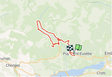
Embrun-Puy St Eusèbe-Réallon station-Les Gourniers

nicolas54230
User

Length
28 km

Max alt
1614 m

Uphill gradient
830 m
Km-Effort
39 km

Min alt
1136 m

Downhill gradient
845 m
Boucle
Yes
Creation date :
2025-08-01 12:12:33.645
Updated on :
2025-08-01 12:13:33.041
2h43
Difficulty : Difficult

FREE GPS app for hiking
 SityTrail
IGN / Geographical institutes
SityTrail Plus
The world is yours!
About
Trail Mountain bike of 28 km to be discovered at Provence-Alpes-Côte d'Azur, Hautes-Alpes, Puy-Saint-Eusèbe. This trail is proposed by nicolas54230.
Positioning
Country:
France
Region :
Provence-Alpes-Côte d'Azur
Department/Province :
Hautes-Alpes
Municipality :
Puy-Saint-Eusèbe
Location:
Unknown
Start:(Dec)
Start:(UTM)
294415 ; 4937625 (32T) N.
Comments