


Montpellier Torride

stef789
User GUIDE
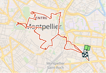

Length
8.6 km

Max alt
63 m

Uphill gradient
92 m
Km-Effort
9.8 km

Min alt
19 m

Downhill gradient
100 m
Boucle
No
Creation date :
2025-08-02 10:30:49.961
Updated on :
2025-08-02 14:05:00.917
3h33
Difficulty : Medium

FREE GPS app for hiking
 SityTrail
IGN / Geographical institutes
SityTrail Plus
The world is yours!
About
Trail Walking of 8.6 km to be discovered at Occitania, Hérault, Montpellier. This trail is proposed by stef789.
Photos


53 photos in total. Please click on a photo to see them all in the gallery.
Positioning
Country:
France
Region :
Occitania
Department/Province :
Hérault
Municipality :
Montpellier
Location:
Unknown
Start:(Dec)
Start:(UTM)
571693 ; 4828411 (31T) N.
Comments