


wandelingDion1

Dries Naulaers
User
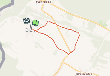

Length
5.3 km

Max alt
258 m

Uphill gradient
83 m
Km-Effort
6.4 km

Min alt
184 m

Downhill gradient
80 m
Boucle
Yes
Creation date :
2025-08-03 08:08:54.862
Updated on :
2025-08-03 09:17:14.992
1h07
Difficulty : Easy

FREE GPS app for hiking
 SityTrail
IGN / Geographical institutes
SityTrail Plus
The world is yours!
About
Trail Walking of 5.3 km to be discovered at Wallonia, Namur, Beauraing. This trail is proposed by Dries Naulaers.
Positioning
Country:
Belgium
Region :
Wallonia
Department/Province :
Namur
Municipality :
Beauraing
Location:
Unknown
Start:(Dec)
Start:(UTM)
635051 ; 5553456 (31U) N.
Comments