


Sérum

ollivier.albert
User
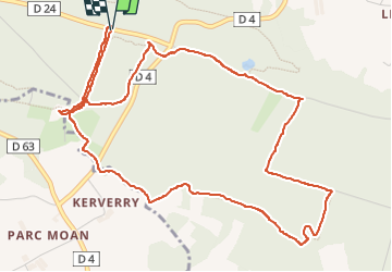

Length
6.5 km

Max alt
249 m

Uphill gradient
102 m
Km-Effort
7.8 km

Min alt
189 m

Downhill gradient
102 m
Boucle
Yes
Creation date :
2025-08-03 13:33:20.056
Updated on :
2025-08-03 15:38:49.069
1h52
Difficulty : Easy

FREE GPS app for hiking
 SityTrail
IGN / Geographical institutes
SityTrail Plus
The world is yours!
About
Trail Walking of 6.5 km to be discovered at Brittany, Côtes-d'Armor, Lanrodec. This trail is proposed by ollivier.albert.
Positioning
Country:
France
Region :
Brittany
Department/Province :
Côtes-d'Armor
Municipality :
Lanrodec
Location:
Unknown
Start:(Dec)
Start:(UTM)
495390 ; 5370055 (30U) N.
Comments