


Chalet des Bannettes par le col de la Charmette en boucle - 9 juin 2025

morganee
User
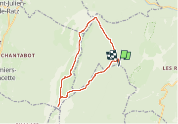

Length
15 km

Max alt
1754 m

Uphill gradient
702 m
Km-Effort
24 km

Min alt
1276 m

Downhill gradient
701 m
Boucle
Yes
Creation date :
2025-06-09 06:50:54.079
Updated on :
2025-08-04 10:48:40.538
6h14
Difficulty : Medium

FREE GPS app for hiking
 SityTrail
IGN / Geographical institutes
SityTrail Plus
The world is yours!
About
Trail Walking of 15 km to be discovered at Auvergne-Rhône-Alpes, Isère, Proveysieux. This trail is proposed by morganee.
Positioning
Country:
France
Region :
Auvergne-Rhône-Alpes
Department/Province :
Isère
Municipality :
Proveysieux
Location:
Unknown
Start:(Dec)
Start:(UTM)
714701 ; 5022289 (31T) N.
Comments