


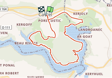
Lac de Guerlédan et bois de Caurel - 04 août 2025

morganee
User

Length
11.1 km

Max alt
192 m

Uphill gradient
210 m
Km-Effort
13.9 km

Min alt
121 m

Downhill gradient
210 m
Boucle
Yes
Creation date :
2025-08-04 10:57:00.34
Updated on :
2025-08-04 14:52:06.758
3h20
Difficulty : Medium

FREE GPS app for hiking
 SityTrail
IGN / Geographical institutes
SityTrail Plus
The world is yours!
About
Trail Walking of 11.1 km to be discovered at Brittany, Côtes-d'Armor, Caurel. This trail is proposed by morganee.
Description
Très belle rando, dans les bois et le long du rivage du lac.
Pas de difficulté, si ce n'est effectivement quelques raidillons assez courts (d'où loin classement en "moyenne")
Positioning
Country:
France
Region :
Brittany
Department/Province :
Côtes-d'Armor
Municipality :
Caurel
Location:
Unknown
Start:(Dec)
Start:(UTM)
497352 ; 5340307 (30U) N.
Comments