


Abriès-Brunissard-Clapeyto chalets-Lac de Néal

nicolas54230
User
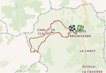

Length
15.6 km

Max alt
2539 m

Uphill gradient
939 m
Km-Effort
28 km

Min alt
1805 m

Downhill gradient
939 m
Boucle
Yes
Creation date :
2025-08-04 18:25:15.985
Updated on :
2025-08-04 18:26:44.854
6h22
Difficulty : Medium

FREE GPS app for hiking
 SityTrail
IGN / Geographical institutes
SityTrail Plus
The world is yours!
About
Trail On foot of 15.6 km to be discovered at Provence-Alpes-Côte d'Azur, Hautes-Alpes, Arvieux. This trail is proposed by nicolas54230.
Positioning
Country:
France
Region :
Provence-Alpes-Côte d'Azur
Department/Province :
Hautes-Alpes
Municipality :
Arvieux
Location:
Unknown
Start:(Dec)
Start:(UTM)
320045 ; 4962669 (32T) N.
Comments