


corrençon

raygautier
User
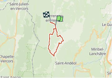

Length
17 km

Max alt
2048 m

Uphill gradient
1052 m
Km-Effort
31 km

Min alt
1127 m

Downhill gradient
1166 m
Boucle
No
Creation date :
2025-08-04 06:28:59.0
Updated on :
2025-08-04 18:51:43.871
8h55
Difficulty : Very difficult

FREE GPS app for hiking
 SityTrail
IGN / Geographical institutes
SityTrail Plus
The world is yours!
About
Trail Walking of 17 km to be discovered at Auvergne-Rhône-Alpes, Isère, Corrençon-en-Vercors. This trail is proposed by raygautier.
Positioning
Country:
France
Region :
Auvergne-Rhône-Alpes
Department/Province :
Isère
Municipality :
Corrençon-en-Vercors
Location:
Unknown
Start:(Dec)
Start:(UTM)
699294 ; 4988217 (31T) N.
Comments