


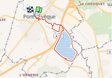
2025-08-05 Rando Pont l'évêque - Repas Eden Park

jchezlemas
User

Length
7.8 km

Max alt
17 m

Uphill gradient
35 m
Km-Effort
8.3 km

Min alt
7 m

Downhill gradient
35 m
Boucle
Yes
Creation date :
2025-08-05 07:55:26.35
Updated on :
2025-08-05 17:33:16.086
1h53
Difficulty : Medium

FREE GPS app for hiking
 SityTrail
IGN / Geographical institutes
SityTrail Plus
The world is yours!
About
Trail Walking of 7.8 km to be discovered at Normandy, Calvados, Pont-l'Évêque. This trail is proposed by jchezlemas.
Positioning
Country:
France
Region :
Normandy
Department/Province :
Calvados
Municipality :
Pont-l'Évêque
Location:
Pont-l'Évêque
Start:(Dec)
Start:(UTM)
295045 ; 5463050 (31U) N.
Comments