


Queyras-Echalp-Col Lacroix-Pic Praroussin

nicolas54230
User
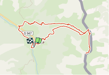

Length
12.1 km

Max alt
2637 m

Uphill gradient
974 m
Km-Effort
25 km

Min alt
1662 m

Downhill gradient
975 m
Boucle
Yes
Creation date :
2025-08-06 06:24:42.77
Updated on :
2025-08-06 06:25:41.537
5h42
Difficulty : Very difficult

FREE GPS app for hiking
 SityTrail
IGN / Geographical institutes
SityTrail Plus
The world is yours!
About
Trail Walking of 12.1 km to be discovered at Provence-Alpes-Côte d'Azur, Hautes-Alpes, Abriès-Ristolas. This trail is proposed by nicolas54230.
Positioning
Country:
France
Region :
Provence-Alpes-Côte d'Azur
Department/Province :
Hautes-Alpes
Municipality :
Abriès-Ristolas
Location:
Ristolas
Start:(Dec)
Start:(UTM)
341125 ; 4957968 (32T) N.
Comments