


Queyras-Abriès-Mt Dauphin Citadelle

nicolas54230
User
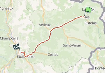

Length
36 km

Max alt
1574 m

Uphill gradient
722 m
Km-Effort
47 km

Min alt
918 m

Downhill gradient
1251 m
Boucle
No
Creation date :
2025-08-06 12:05:44.528
Updated on :
2025-08-06 12:06:19.461
0m
Difficulty : Very easy

FREE GPS app for hiking
 SityTrail
IGN / Geographical institutes
SityTrail Plus
The world is yours!
About
Trail Cycle of 36 km to be discovered at Provence-Alpes-Côte d'Azur, Hautes-Alpes, Abriès-Ristolas. This trail is proposed by nicolas54230.
Positioning
Country:
France
Region :
Provence-Alpes-Côte d'Azur
Department/Province :
Hautes-Alpes
Municipality :
Abriès-Ristolas
Location:
Unknown
Start:(Dec)
Start:(UTM)
336076 ; 4962415 (32T) N.
Comments