


lans en vercors

raygautier
User
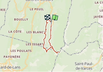

Length
11.1 km

Max alt
1734 m

Uphill gradient
582 m
Km-Effort
18.9 km

Min alt
1275 m

Downhill gradient
592 m
Boucle
Yes
Creation date :
2025-08-06 05:59:49.0
Updated on :
2025-08-06 12:54:27.772
6h53
Difficulty : Difficult

FREE GPS app for hiking
 SityTrail
IGN / Geographical institutes
SityTrail Plus
The world is yours!
About
Trail Walking of 11.1 km to be discovered at Auvergne-Rhône-Alpes, Isère, Lans-en-Vercors. This trail is proposed by raygautier.
Positioning
Country:
France
Region :
Auvergne-Rhône-Alpes
Department/Province :
Isère
Municipality :
Lans-en-Vercors
Location:
Unknown
Start:(Dec)
Start:(UTM)
704796 ; 4998120 (31T) N.
Comments