


3 lacs

Claude Luchetta
User
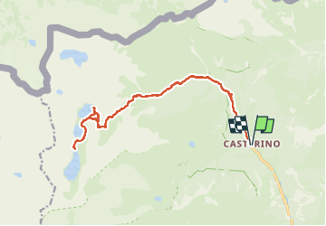

Length
19.5 km

Max alt
2345 m

Uphill gradient
854 m
Km-Effort
31 km

Min alt
1554 m

Downhill gradient
853 m
Boucle
Yes
Creation date :
2025-08-07 06:41:40.965
Updated on :
2025-08-07 14:30:43.176
7h19
Difficulty : Medium

FREE GPS app for hiking
 SityTrail
IGN / Geographical institutes
SityTrail Plus
The world is yours!
About
Trail Walking of 19.5 km to be discovered at Provence-Alpes-Côte d'Azur, Maritime Alps, Tende. This trail is proposed by Claude Luchetta.
Positioning
Country:
France
Region :
Provence-Alpes-Côte d'Azur
Department/Province :
Maritime Alps
Municipality :
Tende
Location:
Unknown
Start:(Dec)
Start:(UTM)
380448 ; 4883870 (32T) N.
Comments