


fleurieu 250808

ppn
User
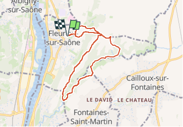

Length
7.7 km

Max alt
286 m

Uphill gradient
214 m
Km-Effort
10.6 km

Min alt
181 m

Downhill gradient
213 m
Boucle
Yes
Creation date :
2025-08-08 06:28:38.806
Updated on :
2025-08-08 10:09:56.818
2h24
Difficulty : Medium

FREE GPS app for hiking
 SityTrail
IGN / Geographical institutes
SityTrail Plus
The world is yours!
About
Trail Walking of 7.7 km to be discovered at Auvergne-Rhône-Alpes, Métropole de Lyon, Fleurieu-sur-Saône. This trail is proposed by ppn.
Positioning
Country:
France
Region :
Auvergne-Rhône-Alpes
Department/Province :
Métropole de Lyon
Municipality :
Fleurieu-sur-Saône
Location:
Unknown
Start:(Dec)
Start:(UTM)
643349 ; 5080508 (31T) N.
Comments