


rando-10-08-25-nre-et-pch-manderfeld-40-km

Macka
User
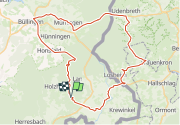

Length
41 km

Max alt
683 m

Uphill gradient
585 m
Km-Effort
48 km

Min alt
490 m

Downhill gradient
581 m
Boucle
Yes
Creation date :
2025-08-08 09:52:25.202
Updated on :
2025-08-08 09:52:25.202

FREE GPS app for hiking
 SityTrail
IGN / Geographical institutes
SityTrail Plus
The world is yours!
About
Trail of 41 km to be discovered at Wallonia, Liège, Büllingen. This trail is proposed by Macka.
Points of interest


Positioning
Country:
Belgium
Region :
Wallonia
Department/Province :
Liège
Municipality :
Büllingen
Location:
Unknown
Start:(Dec)
Start:(UTM)
308865 ; 5579949 (32U) N.
Comments