


Ayla

Tommy Eric
User

Length
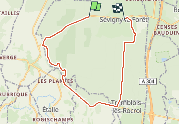
14.2 km

Max alt
369 m

Uphill gradient
253 m
Km-Effort
17.6 km

Min alt
248 m

Downhill gradient
247 m
Boucle
No
Creation date :
2025-08-08 14:05:39.827
Updated on :
2025-08-08 15:20:32.144
1h09
Difficulty : Easy

FREE GPS app for hiking
 SityTrail
IGN / Geographical institutes
SityTrail Plus
The world is yours!
About
Trail Mountain bike of 14.2 km to be discovered at Grand Est, Ardennes, Sévigny-la-Forêt. This trail is proposed by Tommy Eric.
Description
Ayla
Positioning
Country:
France
Region :
Grand Est
Department/Province :
Ardennes
Municipality :
Sévigny-la-Forêt
Location:
Unknown
Start:(Dec)
Start:(UTM)
605604 ; 5527300 (31U) N.
Comments