


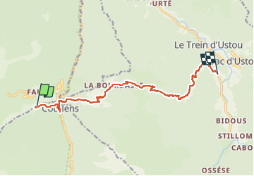
GR10 J13 camping Berièr- St.Lisier

werth
User

Length
13.6 km

Max alt
1551 m

Uphill gradient
855 m
Km-Effort
25 km

Min alt
705 m

Downhill gradient
915 m
Boucle
No
Creation date :
2025-08-08 06:33:21.697
Updated on :
2025-08-08 19:31:09.739
7h49
Difficulty : Difficult

FREE GPS app for hiking
 SityTrail
IGN / Geographical institutes
SityTrail Plus
The world is yours!
About
Trail Walking of 13.6 km to be discovered at Occitania, Ariège, Couflens. This trail is proposed by werth.
Positioning
Country:
France
Region :
Occitania
Department/Province :
Ariège
Municipality :
Couflens
Location:
Unknown
Start:(Dec)
Start:(UTM)
350768 ; 4738876 (31T) N.
Comments