


vattetot

philberard95
User
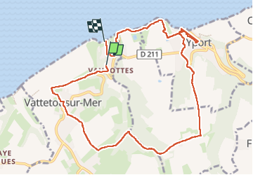

Length
10.6 km

Max alt
97 m

Uphill gradient
203 m
Km-Effort
13.4 km

Min alt
1 m

Downhill gradient
235 m
Boucle
No
Creation date :
2025-07-24 08:25:19.035
Updated on :
2025-08-09 12:19:27.251
2h54
Difficulty : Difficult

FREE GPS app for hiking
 SityTrail
IGN / Geographical institutes
SityTrail Plus
The world is yours!
About
Trail Walking of 10.6 km to be discovered at Normandy, Seine-Maritime, Vattetot-sur-Mer. This trail is proposed by philberard95.
Positioning
Country:
France
Region :
Normandy
Department/Province :
Seine-Maritime
Municipality :
Vattetot-sur-Mer
Location:
Unknown
Start:(Dec)
Start:(UTM)
304786 ; 5512611 (31U) N.
Comments