


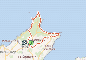
Fort La Latte et Cap Fréhel depuis Plévenon - 09 août 2025

morganee
User

Length
15.9 km

Max alt
77 m

Uphill gradient
204 m
Km-Effort
18.6 km

Min alt
25 m

Downhill gradient
204 m
Boucle
Yes
Creation date :
2025-08-09 09:20:51.26
Updated on :
2025-08-09 17:00:49.735
5h00
Difficulty : Easy

FREE GPS app for hiking
 SityTrail
IGN / Geographical institutes
SityTrail Plus
The world is yours!
About
Trail Walking of 15.9 km to be discovered at Brittany, Côtes-d'Armor, Plévenon. This trail is proposed by morganee.
Description
Aucune difficulté technique, si ce n'est éventuellement la longueur du parcours.
Positioning
Country:
France
Region :
Brittany
Department/Province :
Côtes-d'Armor
Municipality :
Plévenon
Location:
Unknown
Start:(Dec)
Start:(UTM)
549150 ; 5389160 (30U) N.
Comments